
Krzemionki: Underground Route in the Footsteps of Neolithic Flint Miners
Krzemionki, near Ostrowiec Świętokrzyski in central Poland, preserves a prehistoric mining landscape that is difficult to compare with an ordinary archaeological site. Thousands of years ago, people came here to extract striped flint from limestone beneath the ground, using the material mainly to make axes and other tools. Mining continued from roughly 3900 to 1600 BCE, covering much of the Neolithic period and reaching into the Early Bronze Age. Today, visitors can pass below ground on a specially prepared route running beside and through sections of the ancient workings. The site has been on the UNESCO World Heritage List since 2019 and combines original mining remains with museum displays, a forest route and a reconstructed prehistoric settlement. For travellers interested in Polish history, archaeology or places that retain a strong physical connection with the distant past, Krzemionki offers far more than a conventional exhibition behind glass.
Why Krzemionki Matters in Poland’s Prehistoric Landscape
The scale of mining at Krzemionki is the first reason the site is so important. The prehistoric mining field forms a long arc extending for approximately 4.5 kilometres, and archaeologists estimate that more than 4,000 shafts and extraction pits once operated within it. Some were comparatively simple, while others led to larger underground spaces where miners followed the layer containing striped flint. The main period of intensive production came thousands of years before metal tools became common in this part of Europe. The surviving landscape therefore provides unusually direct evidence of how organised communities could obtain valuable raw material using stone, flint, antler and wooden equipment. Surface remains are significant too: old shaft depressions, waste heaps and traces of work areas help archaeologists reconstruct the layout of a mining district rather than a single isolated excavation.
The striped flint itself explains why so much labour was concentrated here. It has distinctive bands in different shades of grey and could be shaped into durable tools, especially axes. During the height of production, rough forms were prepared near the mines before further finishing took place at settlements and workshops elsewhere in the region. Objects made from Krzemionki flint have been found hundreds of kilometres from their source. UNESCO records a distribution radius exceeding 650 kilometres, while the museum gives a figure of about 660 kilometres for finds dating from the period when striped flint was particularly popular. Such distances show that communities living around the present-day Świętokrzyskie region participated in networks of movement and exchange extending far beyond the immediate Kamienna valley. A flint axe was therefore more than a local household object: its raw material could travel across a substantial part of prehistoric Central and Eastern Europe.
Krzemionki is also part of a larger protected archaeological landscape. The UNESCO property consists of four components: the principal Krzemionki Opatowskie mining field, the smaller Borownia and Korycizna mining fields and the prehistoric settlement at Gawroniec in Ćmielów. This wider arrangement links extraction sites with a place where flint was processed and people lived. Modern archaeological interest began in 1922, when Polish geologist and palaeontologist Jan Samsonowicz identified traces of prehistoric mining during fieldwork in the Świętokrzyskie region. Archaeologists soon began systematic investigations and efforts to protect the mines. Krzemionki was designated a Polish Monument of History in 1994, and inscription on the UNESCO World Heritage List followed in 2019. The significance of the site therefore rests not simply on its age but on the exceptional survival of the mines, workshops, surface features and related settlement evidence.
What the Mines Reveal About Neolithic Work and Trade
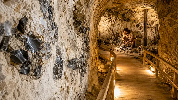
Working below ground at Krzemionki demanded considerable knowledge of the local rock. The valuable flint occurred within a relatively narrow limestone layer, so miners had to reach the correct depth and then follow that layer rather than excavating without a plan. Original underground spaces were generally very low, often between about 55 and 120 centimetres high. Much of the work consequently had to be carried out while kneeling or lying down. Different methods were used in different parts of the mining field, from relatively straightforward pits and small side workings to more extensive chamber systems. Miners also left parts of the rock in place to support ceilings where necessary. What appears simple from the surface was therefore the result of accumulated knowledge about the geology beneath the site and about how far rock could safely be removed.
The equipment was basic by modern standards but suited to the work. Archaeological evidence includes mining tools made from stone, flint and animal antler, together with wooden equipment. Picks, wedges and hammer-like tools helped loosen limestone and release flint nodules from the surrounding rock. Small pieces of resinous wood could provide light underground without producing the amount of smoke expected from a larger fire. Several people were probably involved in operating a mine, sharing jobs such as digging, removing unwanted rock, carrying material towards the shaft and transporting selected flint to the surface. Archaeologists have also identified evidence for wooden structures around some shafts. These could protect openings from weather and make handling material easier. Such details make the site valuable because they reveal everyday organisation as well as prehistoric objects: a mine had to function as a coordinated workplace.
Not every piece of flint removed from the limestone was worth carrying away. Material could be selected underground, leaving poor-quality pieces behind and taking the better nodules to the surface in bags or baskets. Workshops near mine entrances handled the first stages of production, reducing large pieces and preparing forms that could later become axes and chisels. Further work also took place at settlements in the surrounding region. Gawroniec, now one of the four components of the UNESCO property, provides particularly important evidence for intensive flint working. This chain from extraction to preparation and distribution helps explain why Krzemionki is regarded as much more than a collection of old holes in the ground. It preserves evidence of specialised labour, the organisation of raw-material production and long-distance movement at a time when farming communities were becoming firmly established across much of Europe.
What Visitors See on the Underground Route
The underground route at Krzemionki is almost 500 metres long and reaches approximately 11.5 metres below the surface at its deepest point. Visitors do not simply crawl through the extremely low passages used by prehistoric miners. Instead, a purpose-built visitor gallery makes it possible to move through the mining area while seeing authentic workings preserved beside the route. This arrangement is important because many of the original spaces are far too low, fragile or difficult for routine public access. The route passes areas where the relationship between the limestone and the striped-flint layer can be seen clearly, making it easier to understand why shafts were sunk in particular places. Preserved underground chambers also reveal how much material ancient miners could remove while still leaving enough rock to support the ceiling. The museum describes the Krzemionki route as the only site of this particular type regularly open to the wider public.
Public access to the mines developed gradually rather than appearing as a single modern construction. Visitors began entering cleared sections near several shafts during the late 1950s. Archaeological work in the following decades led to the first dedicated underground visitor section, opened in 1985. Another gallery later allowed people to look into a particularly well-preserved chamber mine, and between 2001 and 2004 the separate sections were joined to create the route used today. This history matters because the visitor infrastructure was designed around archaeological remains that had to be protected. At several points the modern passage runs beside ancient excavations rather than replacing them. The contrast makes the route easier to read: the comfortable space used by a visitor today sits beside narrow prehistoric workings where a miner would have spent long periods crouching close to the rock face.
The underground section is only one part of the route. Much of the visit takes place above ground, where a path crosses woodland growing over the former mining field. The uneven prehistoric surface is itself an archaeological feature, with depressions and raised areas marking shafts and spoil from thousands of years of extraction. This landscape can be easy to overlook without an explanation because vegetation has softened many of the shapes, yet its preservation is one of Krzemionki’s major strengths. Visitors move between the museum, the archaeological reserve and the mining area, so the story is presented on several scales at once. Objects show what people made; underground workings show where the raw material came from; and the surface landscape shows how intensive extraction altered a sizeable area long before anything resembling a modern industrial mine existed.
From the Mine Galleries to the Reconstructed Neolithic Settlement
The museum exhibition helps put the underground route into context before or after the descent. Its permanent display, known in Polish as “Władcy Krzemienia”, or “Rulers of Flint”, presents the operation of the mines and the communities associated with them. Archaeological objects are supported by reconstructions and interpretive material that explain how striped flint formed, how it was obtained and what happened to it after extraction. This is particularly useful for visitors without specialist archaeological knowledge. A finished flint axe can look deceptively simple when displayed on its own, while the full visit shows the much longer process behind it: locating suitable deposits, sinking a shaft, working in restricted underground spaces, selecting good raw material and shaping the stone through several stages before it became a usable object.
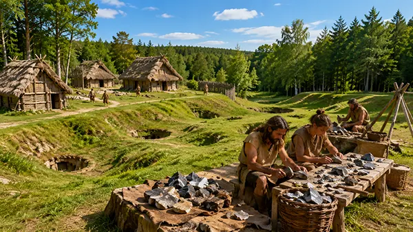
Another part of the visit is the reconstructed prehistoric settlement covering around 1.5 hectares. It includes four reconstructed houses based on archaeological evidence from Neolithic and Early Bronze Age sites, together with a palisade, defensive ditch and other features intended to illustrate settlement life. The buildings represent communities associated with the Funnel Beaker, Globular Amphora and Mierzanowice cultures, all linked with phases of activity at the Krzemionki mines. The area is also used for educational demonstrations and experimental archaeology. It gives visitors a sense of the materials and spaces that do not survive as visibly as the stone mines themselves: timber houses, fences and everyday structures normally disappear from the archaeological record far more readily than underground excavations cut into limestone.
It is useful, however, to understand what this reconstructed settlement represents. It is not a literal rebuilding of a village that once stood directly beside the tourist route. The museum explains that the Krzemionki mining field was mainly a place of extraction and temporary activity rather than permanent residence, partly because reliable drinking water was not available there. Evidence points instead to nearby settlements, including Gawroniec at Ćmielów, as important centres connected with the miners and flint workers. The reconstructed houses therefore combine archaeological knowledge from several prehistoric sites to show how communities of the period may have organised living space. This distinction makes the reconstruction more informative, not less: visitors can separate what has survived in its original position underground from modern structures created to explain the wider human setting of the mines.
Planning a Visit to Krzemionki in 2026
The Archaeological Museum and Krzemionki Reserve is at Sudół 135a, around eight kilometres north-east of Ostrowiec Świętokrzyski, beside regional road 754 between Sudół and Magonie. Travelling by car is straightforward from Ostrowiec Świętokrzyski, and the museum publishes coordinates of 50.972015°N, 21.489269°E. Public transport is also possible. Local buses connect Ostrowiec Świętokrzyski with communities in the direction of Bałtów and neighbouring villages. An additional useful option in 2026 is the dedicated Ostrowiec–Krzemionki–Bałtów bus connection operating from 1 April until 31 October. Travellers relying on public transport should still check the timetable for the date of their visit, as departures are less frequent than urban services. Krzemionki works well as a half-day trip from Ostrowiec, although allowing extra time removes the need to rush between the booked tour, exhibitions and transport connections.
Opening times vary with the season in 2026. Mondays are closed. From January to March and again from November to December, Tuesday opening is 10:00–16:00, while the museum operates from 8:00–16:00 from Wednesday to Sunday, with underground tour departures beginning later in the morning. In April and October, Tuesday remains 10:00–16:00 and Wednesday to Sunday opening is 9:00–17:00. From May through September, Tuesday is 10:00–16:00, Wednesday to Friday 9:00–18:00 and weekends 10:00–18:00. The museum also publishes specific tour departure times, so arriving just before the building closes will not be enough to join an underground visit. For 2026, closure dates include 1 and 6 January, 4–6 April, 1 and 11 November and 24–26 December.
Current 2026 admission is 40 zł for a standard ticket and 25 zł for a reduced ticket. Family tickets cost 90 zł for two adults and one child or 100 zł for two adults and two children. Children under seven are among those entitled to free admission, subject to the museum’s rules, and Tuesday is the free-admission day for all visitors. The guide fee is included in the ticket, and sightseeing takes place with a guide rather than independently. Advance reservation should be treated as part of planning the trip, especially at weekends, during school holidays or around special events. Reservations can be made by telephone or email through the museum. Visitors who want an English-language tour should request it when making the booking rather than assuming that an English guide will automatically be available at every departure.
What to Wear, How Long to Allow and Who Can Use the Route
A normal visit lasts approximately one and a half to two hours and includes museum exhibitions, the visitor route with its underground section and the reconstructed prehistoric settlement. The most important clothing consideration is temperature. The underground environment remains at roughly 7–9°C even when summer conditions outside are much warmer. A jumper, light jacket or other warm layer is therefore useful throughout the year. Part of the route also runs outdoors through the forest, so footwear suitable for walking is a better choice than shoes intended only for indoor sightseeing. On wet days, visitors should remember that the contrast can be substantial: the museum and underground route are sheltered, while the surface part still involves moving through a natural reserve.
Krzemionki has also been adapted to make substantial parts of the visit accessible to people with mobility needs. The exhibition building has step-free areas, facilities for wheelchair users and a lift. For the underground mines, a specially accessible section is available, and a lift at the Zenon shaft enables visitors who have difficulty using stairs to reach the mine level. Anyone intending to use a wheelchair on the underground part should mention this while booking so that the visit can be organised correctly. The permanent exhibition also includes accessibility features such as tactile replicas, large-print material, Braille and audio elements. Families with very young children should note that pushchairs cannot be taken through all parts of the route because of winding stairs and must be left in designated areas.
Photography for private use is permitted under the museum’s current visitor rules, but flash must not be used underground. Visitors are also expected to remain with the guide and follow the designated route because the archaeological structures and the surrounding nature reserve are legally protected. These rules are not simply museum formalities: many of the underground surfaces and mining remains have survived for several thousand years, and only a small part of the entire prehistoric complex has been prepared for regular public access. Planning around the booked tour, allowing enough time for the museum and reconstructed settlement, and bringing clothing suitable for both the cool mine and the outdoor section makes the visit considerably easier. The result is a clear view of how a prehistoric raw material connected geology, skilled labour, settlement life and long-distance exchange across Europe.
Popular articles
-
Krzemionki: Underground Route in the Footsteps of Neolithic Flint Miners
Krzemionki, near Ostrowiec Świętokrzyski in central Poland, preserves a prehistoric …
-
 Wooden Tserkvas of the Carpathian Region: A Route through Radruż, Chot...
The wooden tserkvas of south-eastern Poland are not simply picturesque …
-
 Historical Reconstructions and Knight Festivals in Poland 2026: A Trav...
Poland remains one of Europe’s leading destinations for historical reenactments …